Introduction - Island origin and fate
The Hawaiian Islands are formed one-by-one as the ocean floor (Pacific Plate) moves slowly toward the northwest over a volcanic hot spot that extrudes molten lava above the surface of the sea. Over a period of about 28 million years, the result has been a string of islands stretching more than 1,600 miles from the Island of Hawaii in the southeast to Midway and Kure atolls in the northwest (Figure 1).
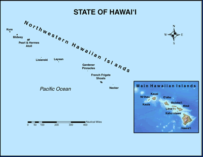
Figure 1. Map of the Hawaiian Islands. This Atlas is focused on the watersheds and streams of the Main Hawaiian Islands.
Similar linear patterns in the dispersal of islands and seamounts are evident among the Line Islands, the Tuamotus, the Marshall-Ellice Island Chain, and others to the west and south of the Hawaiian Archipelago. All these islands share a common destiny. Even before island-building volcanism ceases, erosion from wind, rain, and sea set each island on an inevitable course toward eventual submersion back below the ocean’s surface. In the last stages of the degradation of an island, it may develop a fringe of coral which persists as a doughnut-shaped atoll after the land mass has finally worn down beneath the sea. This conveyor-belt model for the formation and extinction of volcanic islands is overly simplistic because of the variation that occurs in the history of individual islands. However, the trend is generally acknowledged, and it is well illustrated by the islands that form the Hawaiian chain. Coral atolls are predominant in the geologically older Northwestern Hawaiian Islands while volcanic high islands are the major features in the younger southeastern section. It is only these high islands at the bottom of the chain that have well-defined watersheds and perennial streams, the two subjects of paramount concern for the Watershed Atlas.